COAST: Altitude as a Coupled Perception Variable in Shared-Camera Aerial-Ground Tracking
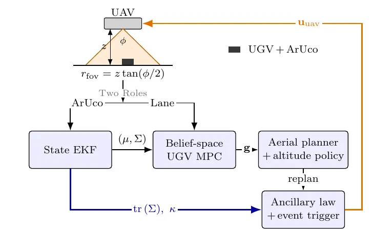
One downward camera on a drone (UAV) is the only sensor of a ground robot (UGV). Each image gives both the lane waypoint for navigation and the marker pose for localisation, so one variable, the UAV altitude, sets both. Flying higher widens the view, but the localisation noise grows as R ∝ z2. COAST treats altitude as a perception variable: we find the best altitude in closed form, state exactly when changing it along the path helps, and cut planner computation with event triggering.
The same frame gives the navigation waypoint (from the segmented lane) and the EKF pose measurement (from the ArUco marker on the UGV). Low altitude gives better localisation; high altitude keeps more of the lane in view.
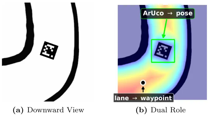
The estimation-optimal altitude is the lowest one that keeps the searched lane region inside the camera footprint (the coverage floor), and it rises with path curvature when the search region grows in turns. A changing altitude beats every fixed altitude only when this floor is active and changes along the path; otherwise one fixed altitude is already optimal.
An EKF fuses the marker pose with wheel odometry. A belief-space MPC drives the UGV and penalises its own predicted uncertainty. The UAV's aerial planner sets position and altitude, and an ancillary feedback law tracks the plan between re-plans. The planner re-solves only on events (tube exit, uncertainty spike, a turn ahead, drift, or an expiring plan), with a bounded tracking error between events.
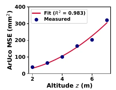
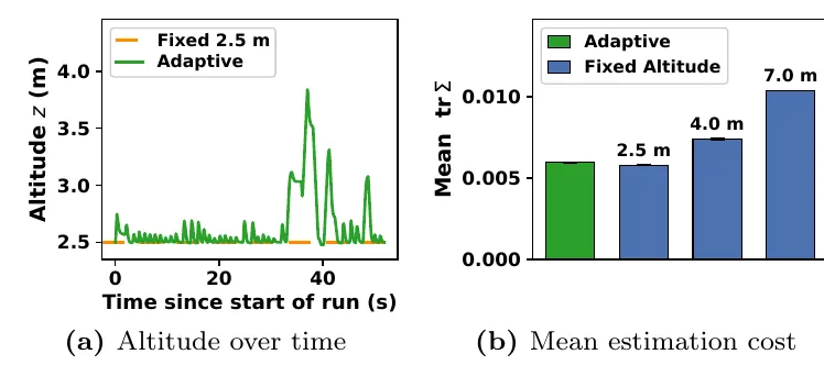
In ROS 2/Gazebo, the marker position error follows the predicted z2 law (R2 = 0.983 over 2–7 m). On our tracks the coverage floor stays constant, and as the theory predicts, the adaptive policy ties with the best fixed altitude (within 2.8%). Event triggering needs 24.9× fewer planner solves and 12.3× less planner CPU time than re-solving at 20 Hz, at the same estimation quality.
My part
I built and ran the ROS 2/Gazebo testbed and the experiments, and worked on the result analysis and the paper text. The first three authors contributed equally.
Scope
All results are from software-in-the-loop simulation: the UAV is a velocity-controlled point mass with a nadir camera, with no rotor or attitude dynamics, wind, camera tilt or realistic image noise, and the UAV pose is ground truth. Next steps are tracks where the coverage floor changes along the path, and hardware tests with a full multicopter model.
This project was funded by ANRF (Project No. ANRF/ARG/2025/007351/ENS).